
I was up at 07.30 UT on Monday morning. Outside there was a light dusting of snow on the ground which was disappointing as I was expecting several inches by now. The sky was clear with scattered clouds and it was freezing!, walking to the west of my house the air had horrendous wind chill which cut through every fibre of clothing. There was a very impressive line of convection in the north with towering white congestus mushrooms rising up with the lead cell forming a very nice anvil. I could only see parts of the anvil as it passed in the gaps between my neighbours houses so I rang Conor who was already watching them from a high window. He confirmed the impressive appearance. It was too early yet to meet up so we decided to wait until we seen some action. From here on things began to get depressing. I spent hours watching the sky while checking the data on the net and nothing was happening. Donegal and the south of Ireland were getting lots of lightning but the satellite images showed nothing heading anywhere near us. When the showers arrived from the Atlantic to the coast they turned to snow and turned active electrically but died out fast as they headed inland. It looked like our chances of seeing any convection were zero. There was nothing in the sky now except some strato cu and a sundog. Conor and I swapped many phone calls for hours during the morning discussing the situation and we came to the conclusion that this was a major disappointment. I got so sick of checking the net for info and seeing nothing. The final blow came in the afternoon when the BBC newsline forecast showed no snow or clouds moving over us at all for the entire day and even into the night. What a let down. I was feeling very bitter at the forecasters and felt like going to bed during the afternoon as I hadn't much sleep the night before. Now the sun was shinning just to rub salt into the emotional wounds.
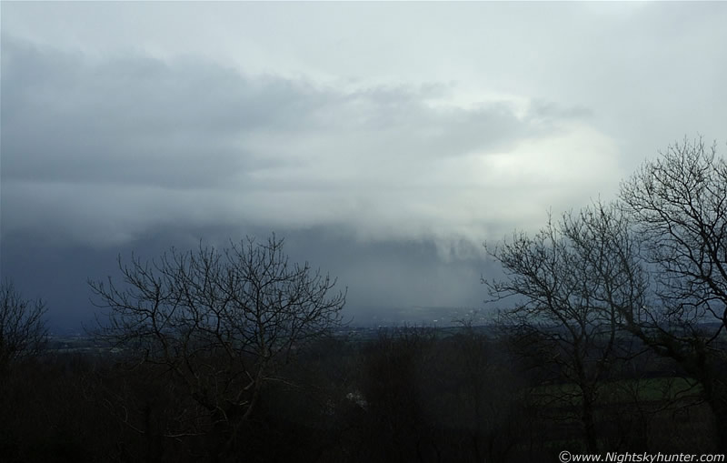
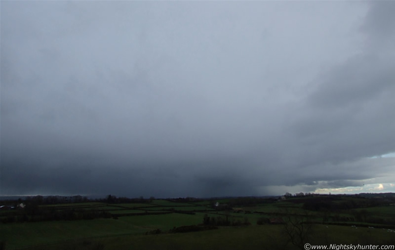
Conor arrived at my door at 13.00 UT. We decided that we wouldn't let this day pass without at least getting some images so we walked out to the countryside. We decided we would look for the majestic Buzzards which circle the sky on good days and try some photography. Now a mile from home and walking down a narrow country road with blue sky above and sun burning, our luck began to improve. Above a small forest were two Buzzards!, this was a good sign as they indicated the presence of invisible updraughts which they glide upon. We got a few shots but with their incredible vision we had no hope of getting closer. They vanished when we made slow progress towards them. We worked our way up through fields, climbing over barbed wire fences looking for something to image. We ended up at a very high vantage point looking down over sweeping green fields. The Coleraine road ran below us and the mountains dominated the skyline with their snowy tops. This was one of our favourite locations. Many a night was spent here watching meteor showers and doing long aurora watches. In daylight its true potential was striking. This is the perfect spot to be watching any storms passing through. The clouds were getting more interesting and several white towers appeared over the crest of the mountains and began heading our way. We began to get a good feeling about this!. If the television forecast was wrong then we would know soon enough.
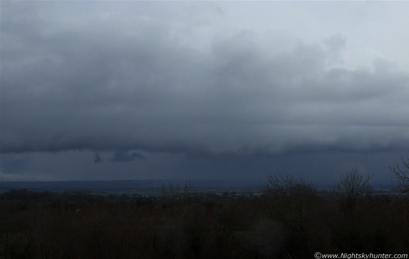
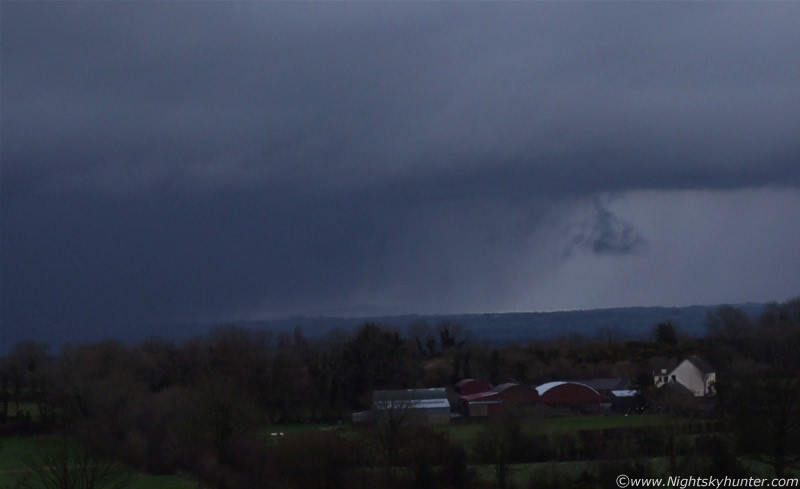
Half an hour later and we had smiles on our faces. Giant cells had suddenly arrived form the N and NW delivering dense white bands of snow, the curtains were enormous like a giant white vertical wall drifting towards us. Behind this was an impenetrable silver mass of the unknown. We were expecting c-gs at any moment. In the SW a wonderful cell with gust front and dense snow core climbed over the mountains and dumped its icy cargo over Maghera. The light levels dropped and it began to get dark. A heavy snow storm hit us with giant snow flakes. These were the biggest snow flakes we had ever seen. They were as a big as or bigger than a ten pence coin. The temp dropped sharply and we were now freezing. Maghera was now invisible. We could just make out the back end of a giant anvil passing through, the size of this cell was so large that we nearly missed it for what it was. The real excitement happened in the NE when an awesome sight emerged out from a region of low visibility. Something big, something severe and menacing looking. As the structure approached we could see that it was a mega gust front with vivid shelf cloud!, this was the first 'proper' gust front we have ever seen and it had a major impact on us. The cell it belonged to extended from the N to SE and overhead. The gust front (GF) was miles long and moved from N to SE at a very slow pace. In fact it was creeping across the land like a Crocodile silently gliding through water to a waiting antelope on the bank. There was something very sinister looking about it. It was strongly curved at the leading edge with visible horizontal striation lines dividing the shelf in two. White complex scud trailed along it's side and evil looking snow and hail bands fell from its underside. The underside itself to the north was a pit of darkness. We seen several suspicious lowering's. One dark wedge-shaped structure narrowed down and seemed to make contact with the ground then it was swallowed up by the darkness. I don't know what it was. The most impressive object was a well defined vertical white funnel-like feature which also seemed to touch the ground. It was soon wrapped in snow and we lost it from view. I have images of this but they are not very good.
I began taking images and video footage which was hard work as my hands were shaking from the cold. We decided to move to another location to get a better view of the GF. Conor and I, with cameras in hand, ran across fields, hopped over many barbed wire fences and ran through a dense forest so we could emerge from the other side at our strategic location. We got scrapped by branches, the wire cut open Conor's ankle and my palm and I fell on the ground twisting the muscles in my back which I can still feel aching now as I write this two days later. In the low light the forest was a creepy place, the strange structures in the trees reminded me of the 'Blair Witch Project', we used to camp here when we were younger and tell ghost stories but today I was glad to get out of it. On the other side still out of breath we began imaging the GF as it retreated into the distance. It was a gorgeous sight and both of us felt suitably impressed by what we had just seen. Keeping in mind that we didn't expect anything it all so this was awesome!. The forecast was wrong. No doubt they would have noticed and made a hasty correction. Later I found out that another severe weather warning had been issued but it didn't matter to us as we seen it first hand. Actually we were on a high!, we came out here depressed and now we felt an incredible sense of achievement. The best we could hope for was a Buzzard, but we ended up with two of them, a mega GF, snow and cells. Dedication pays off and the Eagle-like call of a Buzzard overhead confirmed that. It's funny how things work out. If we had the car we would be on the mountain top covered in dense snow and no visibility at all, however, by a strange twist of fate we ended up here by walking and caught these amazing structures which we would have missed otherwise. Sometimes I think there are higher forces at work here. We do get alot of action here with all kinds of phenomena related to weather and astronomy. Some people would call this good luck, we call it dedication, awareness, sacrifice, and passion. This is what gets results, luck has nothing to do with it.
 |
 |
Some dark scud under the shelf. There was four of these in total at one stage. They showed dynamic movement as they got sucked upward, twisted and curled before our eyes. We seen four strange lowering's. Some of them looked like funnels forming. They were located out of the image to the far left.
 |
 |
 |
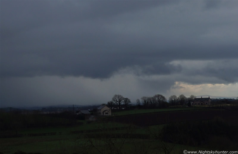
System sailing by us and moving away to the S or slightly west of south. 28mm again here.
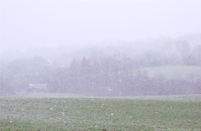 |
Look at the size of the snow flakes. You can see the lights of a distant car and truck on the Coleraine Road.
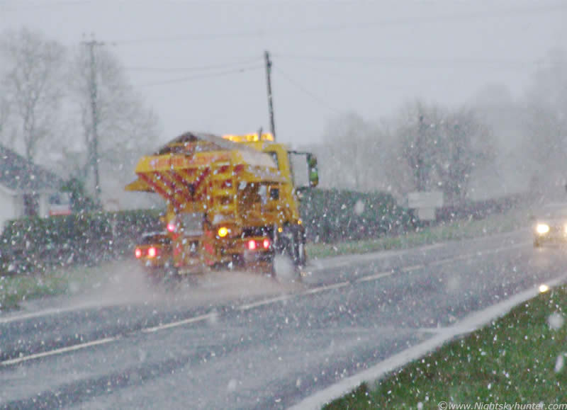 |
Now on the Coleraine Road heading home. I caught this gritter in action. You can see the salt spraying out of the back.
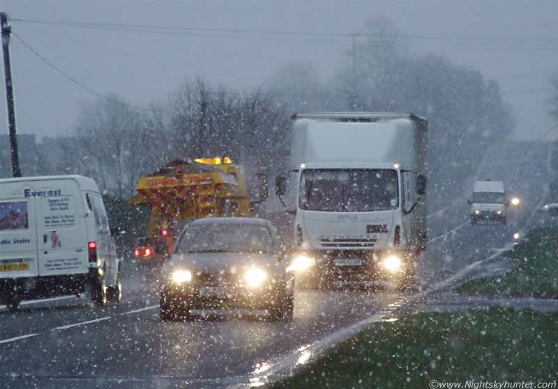 |
More traffic in the snow. Conor told me the driver of that lorry gave me a very strange look!
We walked back home up the Coleraine road where I took a few snaps of the traffic driving through the snow. A large lorry hit a giant muddy puddle at the roadside. The water climbed into the air above our heads like a brown tsunami, I reacted in a split second and turned my back to it as the wave hit us hard soaking us completely. I managed to protect the camera lens which was the main thing. Conor and I then burst into fits of laughter. We ended the session at 17.30 UT as darkness began to fall. I reckoned I had taken maybe 100 images but when I checked the camera I found out the true figure was over 300 along with 12 video clips. It took me a long time going through them. This was not helped by the power going on and off all evening and night due to distance lightning. I actually have much more impressive images of the GF however the focus was out or the top was overexposed so I can't use them. I will have a go and see what I can do with the processing. I hope you enjoy this report, the images, and video footage.
At the time of writing it seems that we might have a major storm coming in on Monday for N. Ireland and parts mainland Britain/Scotland. Could be storm force winds stronger than anything seen during the last 12 months. From friday onwards there is a sharp cold front which could deliver some great convection and even snow so it looks like the weather will be very exciting in the near future. If it happens, I will be watching it!.
An outflow boundary is a storm-scale or mesoscale boundary separating thunderstorm-cooled air (outflow) from the surrounding air; similar in effect to a cold front, with passage marked by a wind shift and usually a drop in temperature. Outflow boundaries may persist for 24 hours or more after the thunderstorms that generated them dissipate, and may travel hundreds of miles from their area of origin. New thunderstorms often develop along outflow boundaries, especially near the point of intersection with another boundary (cold front, dry line, another outflow boundary, etc. A gust front is an outflow boundary that is the leading edge of gusty surface winds from thunderstorm downdrafts; sometimes associated with a shelf cloud or roll cloud. A wrapping gust front is a front that wraps around the mesocyclone, cutting off the inflow of warm moist air and resulting in occlusion. This is sometimes the case during the event of a collapsing storm, in which the wind literally "rips it apart"
Sometimes a gust front can be seen on weather radar, showing as a thin arc or line of weak radar echos pushing out from a collapsing storm. In most cases, these echoes represent insects that have been caught in the colliding winds at the front. Occasionally, winds caused by the gust front are so high in velocity, that they may also show up on radar. This cool outdraft can then energize other storms which it hits by assisting in updrafts. Gust fronts colliding from two storms can even create new storms. However, there is usually no rain accompanying the shifting winds.
A shelf cloud is a low, horizontal wedge-shaped arcus cloud, associated with a thunderstorm gust front (or occasionally with a cold front, even in the absence of thunderstorms). Unlike a roll cloud, a shelf cloud is attached to the base of the parent cloud above it (usually a thunderstorm). Rising cloud motion often can be seen in the leading (outer) part of the shelf cloud, while the underside often appears turbulent and wind-torn. Occasionally people see a shelf cloud and think they have seen a wall cloud, which is an easy mistake, since an approaching shelf cloud appears to form a wall made of cloud. Generally speaking, a shelf cloud appears on the leading edge of a storm, and a wall cloud will usually be at the rear of the storm.
Martin McKenna